ITS Upper Austria
Ziel des Projektes ITS Oberösterreich ist der Betrieb und die Weiterentwicklung eines Echtzeitverkehrslagebildes für das Bundesland Oberösterreich. An der Umsetzung arbeiten die RISC Software GmbH und das FH OÖ Logistikum Steyr. Die RISC Software GmbH ist im Zuge des Projektes für den Betrieb der Datenbankinfrastruktur, die effiziente Einbringung der Echtzeitverkehrsdaten sowie die Ermöglichung von performanten Echtzeitabfragen zuständig.
Diese Abfragen sind zeitkritisch, da eine verspätet ausgelieferte Echtzeitverkehrslage oder Prognose der Verkehrslage – zum Beispiel für die kommende Viertelstunde – keinen Neuheitscharakter mehr besitzt. Durch die von der RISC Software GmbH umgesetzten Optimierungen der eingesetzten Datenbank und Algorithmen ist es möglich, die Verkehrsprognose für ganz Oberösterreich für die nächste Viertelstunde zeitgerecht bereitzustellen. Die Prognose basiert dabei auf in Echtzeit gesammelten und anonymisierten Positionsdaten von Flotten-Fahrzeugen (beispielsweise der Dienstfahrzeuge des Landes Oberösterreich, des ÖAMTC oder des oberösterreichischen Verkehrsverbundes) sowie Daten aus stationären Verkehrszählern (Seitenradare, Induktionsschleifen) und Bluetooth-Sensoren.
Außerdem werden die Echtzeitverkehrslage und die Verkehrsprognosen der Bevölkerung durch Services der Verkehrsauskunft Österreich (VAO) zugänglich gemacht.

Historie / Entwicklung
Das österreichische Projekt EVIS.AT (Echtzeit Verkehrsinformation Straße Österreich, Laufzeit 2015–2022) ist eine wegweisende Initiative zur Verbesserung der Verkehrsinformation auf Österreichs Straßen. Es wurde entwickelt, um Verkehrsteilnehmer*innen aktuelle und präzise Informationen über die Verkehrslage, geplante und ungeplante Ereignisse (z. B. Baustellen oder Unfälle) sowie Verkehrsprognosen in Echtzeit bereitzustellen.
Im 3. Quartal 2022 erfolgte die Überführung in den Betrieb. Seitdem wird EVIS.AT im Rahmen einer öffentlich-öffentlichen Kooperation mit insgesamt 19 Betriebs-Partner*innen (alle neun Bundesländer, BMK, BMI, ASFINAG, ITS Vienna Region, Salzburg Research Forschungs GmbH, RISC Software GmbH, FH OÖ Logistikum, Verkehrsauskunft Österreich VAO GmbH sowie die Städte Wien und Graz) betrieben. Als Teil des EVIS.AT-Betriebskonsortiums übernimmt die Kooperation ITS Upper Austria – bestehend aus dem Land Oberösterreich, dem FH OÖ Logistikum und der RISC Software GmbH – die Aufgaben im Rahmen von EVIS.AT für das Straßennetz in Oberösterreich.
Übersicht & Aufgaben
Die Bereitstellung von Echtzeitverkehrsinformationen spielt eine entscheidende Rolle, um Verkehrsteilnehmer*innen aktuelle und präzise Daten zur Verfügung zu stellen und gleichzeitig die Effizienz des Verkehrsmanagements zu steigern. Die Erzeugung zuverlässiger und hochwertiger Echtzeitinformationen ist jedoch komplex, da sie von verschiedenen Einflussfaktoren abhängt. Dazu gehören unter anderem die Erfassung, Harmonisierung und Bereinigung umfangreicher Verkehrsdaten mit heterogenen Strukturen aus unterschiedlichen Sensortypen.
Die Auswahl geeigneter Datenbanksysteme ist dabei essenziell, insbesondere im Hinblick auf die effiziente Speicherung, Verarbeitung und Analyse der Daten. Das Ziel des Projekts ITS Upper Austria ist daher nicht nur der Betrieb des ITS-Systems, sondern auch die kontinuierliche Weiterentwicklung der Echtzeitverkehrslage und -prognosen für das Bundesland Oberösterreich.
Die Aufgaben von RISC Software GmbH bestehen im Wesentlichen aus der Erfassung der Verkehrsdaten, deren effizienter Verarbeitung und Aufbereitung, der Speicherung und schließlich der Bereitstellung dieser Daten über definierte Schnittstellen. Das Logistikum wiederum übernimmt die qualitative und quantitative Analyse der Daten sowie deren grafische Aufbereitung.
Datenaufbereitung & Speicherung
Die Informationsgewinnung aus Big Data hat in den letzten Jahren auch im Verkehrsbereich stark an Bedeutung gewonnen. Damit Logistikdienstleister*innen in Echtzeit mit Informationen über Reisezeiten, Prognosen, Unfälle und Baustellen versorgt werden können, muss die gesamte Kette – von Erfassung über Übertragung und Zusammenführung bis hin zu Speicherung und Verarbeitung – schnell und effizient funktionieren.
Im Rahmen der Kooperation ITS Upper Austria werden GPS-basierte Floating Cars (FC), Seitenradare, Induktionsschleifen und Bluetooth-Detektoren über verschiedene Schnittstellen angebunden.
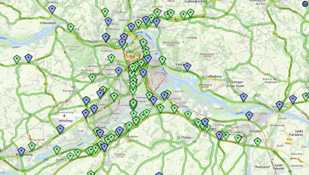
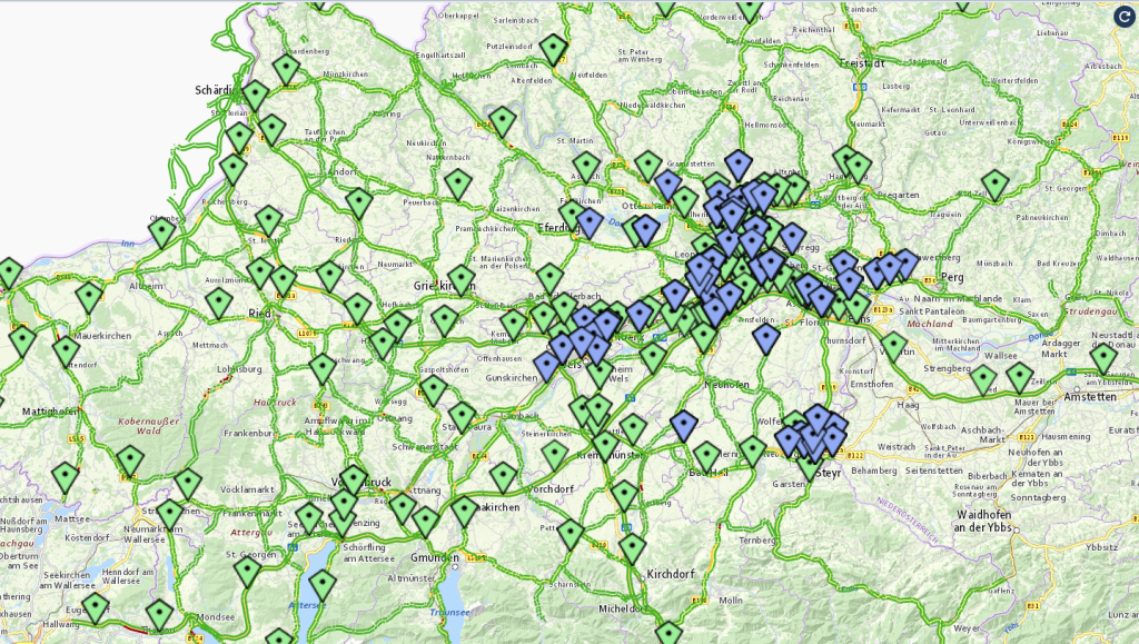
Übersicht der Sensorik (Bluetooth in blau und stationäre in grün) für (rechts) OÖ und (links) Großraum Linz; Screenshot aus TESS
Bevor die Daten nutzbar sind, müssen sie geprüft, bereinigt und anonymisiert werden. Beispielsweise können die Positionsdaten verschiedener FC-Flotten in unterschiedlichen Koordinatensystemen vorliegen. Manche GPS-Empfänger senden fehlerhafte Geschwindigkeitsdaten, liefern aufgrund schlechten Empfangs ungenaue Werte oder verwenden abweichende Zeitzonen.
Seit 2022 hat die RISC Software GmbH verschiedene Speichermöglichkeiten evaluiert, darunter die relationale Datenbank PostgreSQL, die Zeitreihendatenbanken TimescaleDB und Prometheus sowie die NoSQL-Datenbank HBase. Als Ergebnis wurde eine Postgres-Datenbank mit Citus-Erweiterung (Citus-Cluster) ausgewählt, die besonders vielseitig und anpassbar ist. Durch Partitionieren von Tabellen und Hinzufügen von Indizes konnte außerdem die Performance deutlich gesteigert werden, da die Anzahl der Plattenzugriffe erheblich reduziert wurde.
Auf Basis dieser Verkehrsdaten werden Echtzeit-Reisezeiten, Kurz- und Langzeitprognosen sowie Tagesganglinien berechnet. Das im Rahmen von EVIS.AT entwickelte Datensammel- und Verteilsystem (DSVS), betrieben von der Asfinag, dient dabei als Schnittstelle. Die RISC Software GmbH harmonisiert die Verkehrsdaten für Oberösterreich und speist sie automatisiert über die DSVS-Schnittstelle ein. Dadurch trägt sie zur österreichweiten Verfügbarkeit einer aktuellen und konsistenten Verkehrslage bei.
Visualisierung der Qualität von Verkehrsdaten
Ein effizientes Datenmanagement und eine zuverlässige Speicherung sind die Grundlage für präzise Analysen. Es geht dabei jedoch nicht nur um Verwaltung, sondern auch um die Sicherstellung der Validität der Informationen. Deshalb gewinnt die Qualitätsprüfung der Daten zunehmend an Bedeutung. Um eine korrekte Interpretation zu ermöglichen, sind aussagekräftige Visualisierungen hilfreich. Mithilfe verschiedener Dashboards und Tools können Muster erkannt und gezielte Maßnahmen zur Verbesserung der Datenqualität umgesetzt werden. Die Visualisierung und Überprüfung übernimmt hierbei das FH OÖ Logistikum.
Mehrwert
Das Projekt ITS Upper Austria ist als Teil eines größeren Systems zu sehen. Beispielsweise werden die Daten über das DSVS von der VAO abgegriffen und in zahlreiche Dienste eingespeist. Die VAO bietet Bürger*innen eine multimodale Verkehrsauskunft für ganz Österreich. Wer eine Route eingibt, erhält rasch einen Überblick, mit welchem Verkehrsmittel sich das Ziel in welcher Zeit erreichen lässt. Dadurch soll insbesondere der öffentliche Verkehr attraktiver gemacht werden.
Neben dem direkten Nutzen entsteht als internes Ergebnis die Software TESS (Traffic Evaluation & Sensor Statistics). Dieses Programm ermöglicht die Abfrage und Visualisierung der Verkehrsdaten und unterstützt die qualitative Beurteilung. Dabei liegt der Fokus auf aggregierten (Tagesganglinien, V85), historischen und prognostizierten Verkehrsdaten. Prognosen können mit tatsächlichen Geschwindigkeitswerten verglichen werden, außerdem lassen sich Fahrzeugzählungen nach Monaten oder Wochentagen gegenüberstellen.
Somit trägt ITS Upper Austria nicht nur zur besseren Verkehrsplanung bei, sondern stärkt auch die Datensouveränität Österreichs.
Weiterführende Links
Projekt EVIS.AT: Das Projekt EVIS.AT wurde durch die Förderung des Klima- und Energiefonds KliEn ermöglicht. Die Förderung erfolgte im Jahresprogramms 2014 (Programmlinie Verkehr), Programm “Innovation für grüne und effiziente Mobilität – Umsetzungsmaßnahmen im Rahmen des Nationalen Aktionsplans für Intelligente Verkehrssysteme (IVS)”. Das Projekt wurde mit Oktober 2022 beendet und die Aktivitäten, Systeme und Angebote in den dauerhaften Regelbetrieb überführt.
Details zum Projekt
- Projekt-Kurztitel: ITS-UA
- Projekt-Langtitel: ITS Upper Austria: Betrieb von EVIS.AT in Oberösterreich
- Projektpartner*innen: Logistikum
- Budgetvolumen (gesamt): 1,35 Mio EUR
- Laufzeit: 01.01.2022 – 30.06.2026
Kontakt
Projektleitung

Mag. Stefanie Kritzinger-Griebler, PhD
Head of Unit Data Intelligence